
Aims to establish the Geoheritage sites based on richness of fossils from Leh, Kargil, Zanskar and Nyoma, coupled with spectacular mind blowing geological and geomorphological features which throw significant light on the tectonic collision between India and Tibetan plate, today represented as Indus Suture along which the present Indus river flows.

North of Indus is marked by the The Great Batholith of Ladakh and south of Indus is marked by fossiliferous Tethyan sequence in Stok Kangri Range.

The fossils of wood and plant in Ladakh bear close similarity with the Kasauli and molluscs/ oysters with Subathu Formation in Himachal Pradesh this helps in paleolatitudinal position of Indian plate and environmental reconstruction at the time of deposition in the geological past.
Paleoclimatic signatures which form the various interesting Geomorphic landscapes and carve significant structures on hard rocks which help in understanding the paleocliamtic conditions in the past.
Preservation of such deposits is the key to understand climate of the past and lessons which can be learnt for our better future

One such deposit is at Spituk 50 meters of complete section has been dated by various workers in the past to understand the climate change but because of construction and mining the next generation may be devoid of this beautiful source of knowledge. Need of the hour is to preserve and protect this site and declare it as a geoheritage site of geological importance.
GEOHERITAGE sites
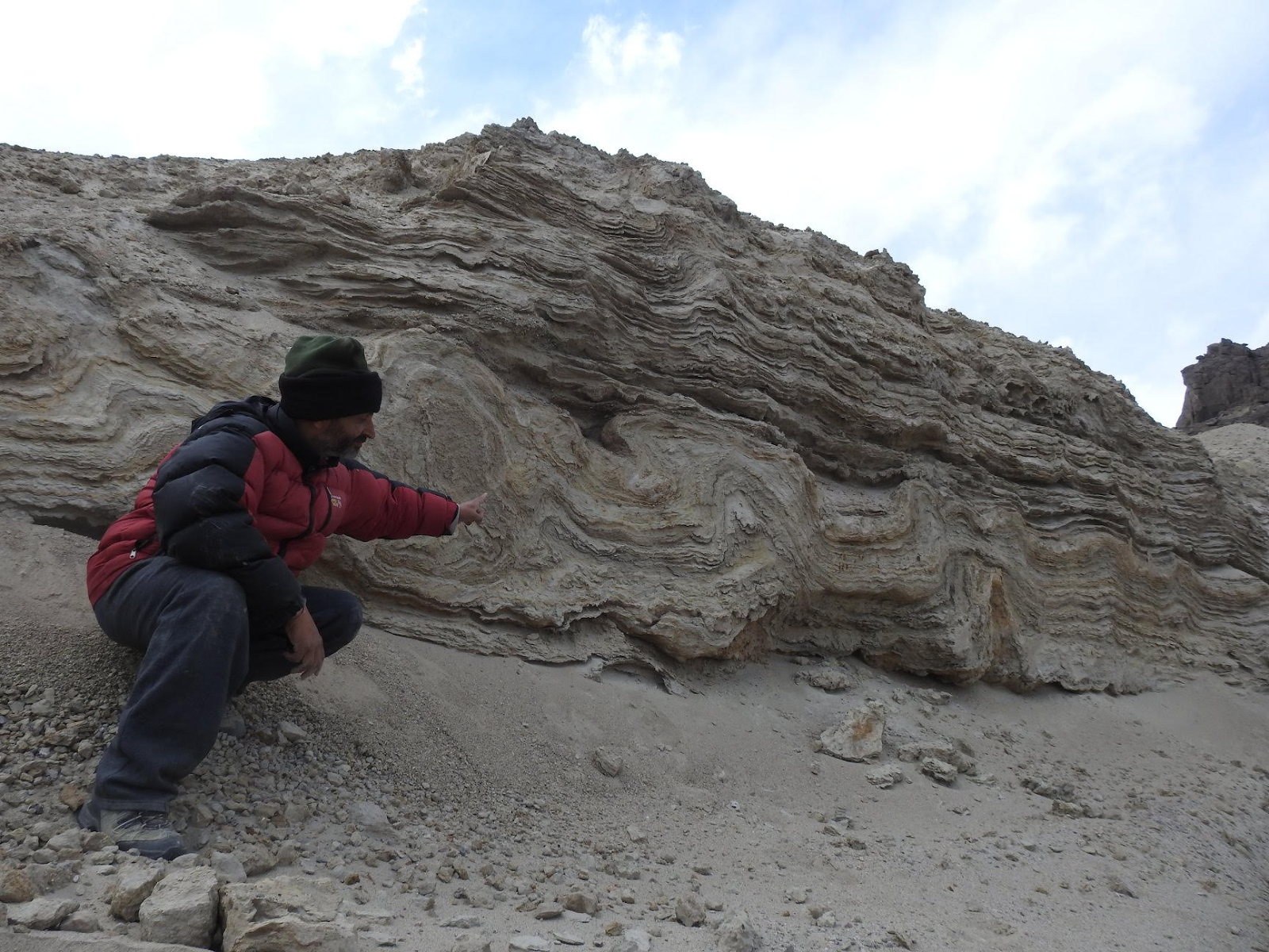
- PALEO EARTHQUAKE SIGNATURES (Seismite) in the paleolake sediments of Leh Ladakh.
The presence of these structures > 1 meter thick convolutes show that the upper portion was also very much disturbed due to seismic activity induced due to seismic movement the vicinity along the Indus Suture Zone.
————————————————————

2 Geothermal springs are represented in Puga, Chumathang and Panamic and Demchuk area and have been used for bathing and washing since time immemorial. Question is when are we going to tap it for energy. Pilot project under IndNor India Norway joint venture helped in space heating of small hotel in Chumathang. Puga is the only geyser in India.
———————————————————

3. The Sand dunes in Nubra in the high altitude cold mountain deserts of Ladakh coupled with double humped camel ride are tourist delight. Their occurrence and formation at Hunder is of significance and the water in the small ponds in the dunes is a marker for the amount of water in the Shyok also known as sorrow of Ladakh India. Magnetic anomalies were

4.Pangong (dead river) and Tsomoriri lake have their own significance in understanding impact of climate change and their Geological and geomorphological evolution

5 Lamayuru – Moonland on earth The glacio fluvial lacustrine environment of the Lamayuru helps in understanding the geomorphology of the area besides building a strong model of climate change and glacial lake outburst around 1006 years ago.

6.Leh Fort and Gompa.Traditional wisdom and knowledge of ancient Lamas in terms of geological know-how in terms of sustainable development is very well reflected in location of monastery and forts. With thier wisdom and technology the ancestors were able to develop and construct 9 story Leh Fort and monasteries like Hemis using local material which have stood the test of time facing innumerable earthquakes and climatic uncertainties including 2010 Floods.

7. Manay walls and Stupas Disaster management skills and ability to mitigate them is seen in construction of Mani walls Chortan and stupas. These walls acted as protection of villages against floods and glacial avalanche Manay wall of Choglamsar protected 100s of houshuld in 2010
8. Paleolakes –Cily of Lakes. Leh was once upon a time from 11000 to 1000 was a city of Lakes This is evident from the paleoglacial deposits we see in Spituk , Shey and on way to Phey and numerous other places.


All these lakes had great importance in past and helped the place to flourish as a TRADE CENTER for travellers on the OLD SILK ROUTE.
GEOHERITAGE SITES Need of the hour is to protect and preserve these sites,so that the site can be preserved for research and education and promotion of geotourism…
Leh 2010 floods was an event which showed that all the new constrcution was damaged due to the sudden flash floods but the OLD structures were hardly toushed by the flash floods.
THEN and NOW


Indian Geoparks Ladakh also
1. Take
steps to inform the local population of the importance of the area where they live in terms of Geological history, educate the interested tourist of the important localities in the area.
2. Establish an international level museum highlighting local and other Indian fossils rocks.
3. Integrate geological, anthropological, archeological, biological, sites/ museum,ecology and ancient monuments and history to achieve geoparks in India
4.To create awareness about conserving and protecting geoheritage sites
5.Make small videos / documentary films on geoheritage and related issues
6. Conduct webinars, conferences, geotours, to create awareness about rich heritage
7. Impart training to students about smart phone apps and Open GIS like QGIS mapillary and Epicollect.
Team formed to protect and preserve Spituk Section in Ladakh
Dr C P Dorjay, Leh Ladakh UT
Dr Binita Phartayal Birbal Sahni Institute of PaleoSciences Lucknow
Dr Rakesh Chandran Ladakh University, Leh
Dr Ravish Lal , Geology Department Delhi University
Mr Mohd Ilyas (Coordinator Ladakh Chapter) Geologist Ladakh
Ms Kunzang Dolma (Coordinator Ladakh Chapter) Ladakh
Initiative by Dr Ritesh Arya
NEWS

